We finally have some nice warm weather. Today we finish our route along Lake Superior at Sault Ste. Marie and the St.Mary’s River into Lake Huron. The topography changes considerably.
We are back into the transportation routes of the original explorers and fur traders. Following historically the evolution of the importance of water routes for the fur trade that opened up the country during the 18th century to sophisticated canal systems, the railroad and then land routes in the 19th century.
It is almost too much to contemplate what was technologically accomplished in this country in such a short period of time… and the importance to its overall development and identity. The amount of manpower needed and the number of immigrants required to make it happen is impressive. They came from everywhere! We owe a debt of appreciation for their perseverance to make Canada what it is today. And an equal apology to the First Nations to what they lost in the doing. There is no gain without a loss.
Sault Ste. Marie, the third-largest city in Northern Ontario after Sudbury and Thunder Bay, is located on the St. Mary’s River on the Canada–US border. To the southwest, across the river, is the United States and the Michigan city of the same name. The two cities are joined by the Sault Ste. Marie International Bridge, which connects Interstate 75 on the Michigan side and Huron Street (and former Ontario Secondary Highway 550B) on the Ontario side. Shipping traffic in the Great Lakes system bypasses the Saint Mary’s Rapids via the American Soo Locks, the world’s busiest canal in terms of tonnage that passes through it, while smaller recreational and tour boats use the Canadian Sault Ste. Marie Canal.


The Sault Canal Emergency Swing Dam is an all-metal structure built by the Dominion Bridge Company in 1896. It sits along the Canadian Sault Ste. Marie Canal, to protect against the rush of water that would occur if something ever damaged the Sault locks. It operates by swinging over the canal and dropping wicket gates into the water. The Emergency Dam was put to the ultimate test on June 9, 1909 when the freighter Perry G. Walker crashed into the upstream lock sending a torrent of water crashing into the downstream lock. The Perry G. Walker and another ship the “Assiniboia” were sent back into the St. Marys River and another ship that was heading upstream out of the locks the “Crescent City” hit the channel wall. The swing dam proved its worth by slowing down the torrent of water. This example of emergency swing bridge is the last of nine ever built. Other examples were previous in Sault Ste. Marie, Michigan, USA and in the Panama Canal.

In 1870, the United States refused to give the steamer Chicona, carrying Colonel Garnet Wolseley, permission to pass through the locks at Sault Ste Marie. In order to control their own water passage, the Canadians constructed the Sault Ste. Marie Canal, which was completed in 1895.

French settlers referred to the rapids on the river as Les Saults de Ste-Marie and the village name was derived from that. The rapids and cascades of the St. Mary’s River descend more than 6 m (20 ft) from the level of Lake Superior to the level of the lower lakes. Hundreds of years ago, this slowed shipping traffic, requiring an overland portage of boats and cargo from one lake to the other. The entire name translates to ‘Saint Mary’s Rapids’ or ‘Saint Mary’s Falls’.
Sault Ste. Marie is one of the oldest French settlements in North America. It was at the crossroads of the 3,000 mile fur trade route, which stretched from Montreal to Sault Ste. Marie and to the North country above Lake Superior.
The city developed considerable industry before and after World War II, especially in steel-making. Algoma (formerly Algoma Steel; Essar Steel Algoma) is the largest single employer. Forestry is also a major local industry.
Famous local person: Roberta Bondar, neurologist and the first Canadian female astronaut in space.
The Lake Superior coastline and surrounding landscape has a strong connection to the Group of Seven. As Canada’s most famous art collective, their works are known across Canada and around the world. From their first painting trips in 1918 to their first exhibition in 1920, to their explorations of the North Shore of Superior, you can learn more via the Group of Seven Touring Route about the Group of Seven.
We have been following this route east since we left Nipigon. I noted the marker in Rossport but there are also markers in other places we have been including Terrace Bay, Pancake Bay etc.
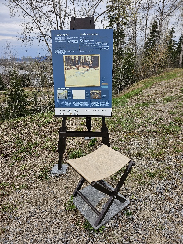

We have travelled the length of this tour now from Nipigon to Blind River. Given the spectacular scenery along the way, its perfectly understandable why an artist would want to spend so much time painting it.
We stopped at the Sunset Family Diner in Thessalon, ON for lunch. It had a lovely view of the beach. We have left behind the magnificent scenery of Lake Superior for scrappy farmland.
Tonight we are camping in Chutes Provincial Park at Massey, ON on the Aux Sables River (sand). And, guess what, another waterfall! The waterfall is considered the main attraction at the park, along with the Seven Sisters Rapids found upstream from the waterfall.


We are cleaning out the refrigerator as we only have a couple of days left. Tonight’s dinner was leftovers. Good leftovers though, ribs, chicken salad, sugar snap peas. We had to stop ourselves from purchasing butter tarts in the restaurant at lunch. I have written about butter tarts before. In the region where my daughter has a weekend cottage, there are butter tart tours. They are an Ontario dessert… nothing like anything in the U.S. despite what my American friends say.

You must be logged in to post a comment.