Beautiful bright sunshine morning after the previous rainy days. It’s still breezy which is a good thing, keeping the fire smoke at bay and no mosquitoes… yet. Still to cool to breakfast outside.
Thunder Bay is situated on Lake Superior at the delta of the Kaministiquia River. Kaministiquia (Gaa-ministigweyaa) is an Ojibwe word meaning “where a stream flows in island” due to two large islands (McKellar and Mission) at the mouth of the river.
Kamanistigouian,” as a place, is first mentioned in a decree of the Conseil Souverain de la Nouvelle-France dated 23 August 1681 instructing one of two canoes to make known the king’s amnesty to coureurs de bois (forest runners). This river was an important part of the water route into western Canada. During the French regime, two fur trading posts were established at the delta of the Kaministiquia. Decades later, a British trading post of Fort William was established here in 1803 by the North West Company at the river’s mouth, and another upstream at Point de Meuron by the Hudson’s Bay Company. The two rival British posts were amalgamated in 1821. The river has had many spellings since 1681, finally being spelled as Kaministiquia.
Fort William Historical Park
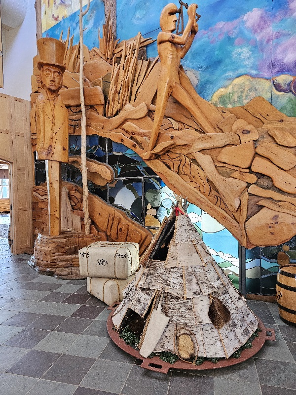
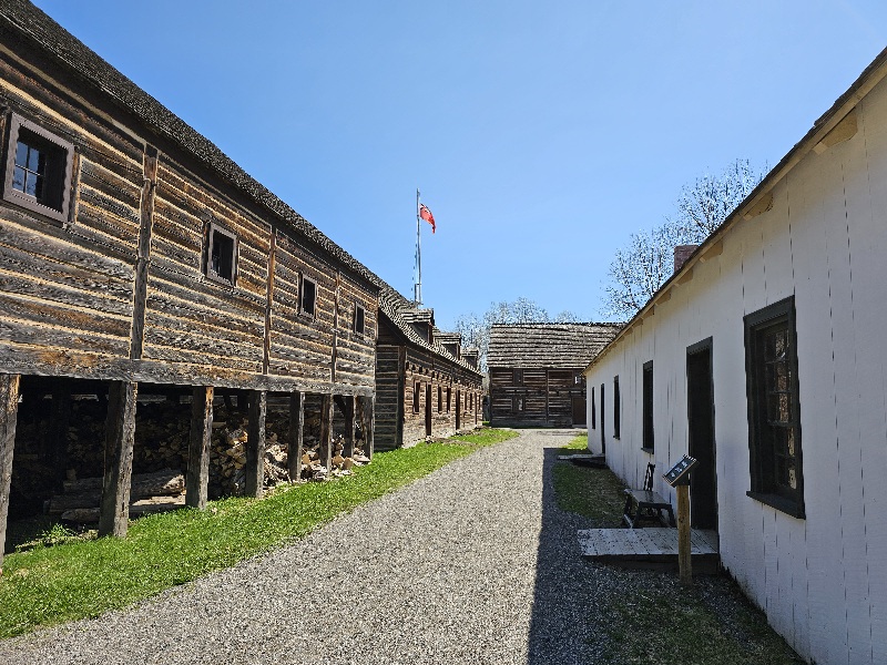
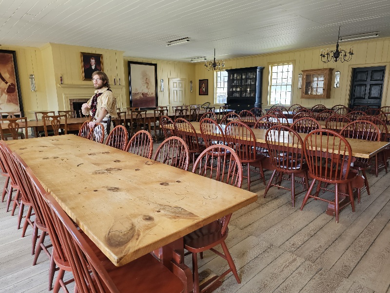
Fort William Historical Park features Fort William, one of North America’s largest living history sites, and the state-of-the-art David Thompson Astronomical Observatory, home to one of the largest telescopes in Central Canada. In 1815, Fort William was the inland headquarters of the North West Company, the world’s largest fur trading enterprise. This was a place where cultures meet, and relationships were forged between Indigenous Peoples and non-Indigenous newcomers. Fort William stands on the traditional territory of the Anishinaabe, the Indigenous people who have lived in harmony with the land for generations, and whose traditions, technologies and customs reflect their relationships with the forests, rivers and animals around them. The Anishinaabe shared their invaluable knowledge and skills with their European partners and trade furs for European goods. Each summer, French-Canadian voyageurs, Scottish businessmen, Indigenous Peoples, and others from around the world gathered at Fort William for the Great Rendezvous to discuss business, shared news and renewed friendships.
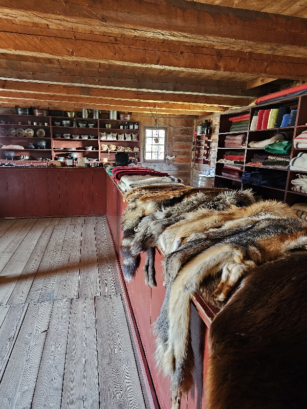
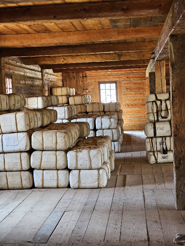
Fort William was not a military Fort but meant for business purposes built to accommodate the partners, the clerks, the guide/translators and native leaders. It had its own farm, business offices, dining halls, billets, workshops, food storage buildings, stores for trading/ purchasing supplies and packing of furs for transport to Montreal. The Great Rendezvous that occurred each summer was when the winter trappers would arrive with their furs. Supplies such as food and clothing would come via canoe from Montreal.
In the early days of the trade, business could be conducted as a there-and-back between Montreal and fur traders. Once the distance grew too great for a round trip in a single season, it required a new model with a rendezvous point in the middle to exchange goods. The large lakers, the canots de maître, were specially constructed for the fur trade to bring trade goods from all over the world to the Fort William depot. The smaller canots du nord, more suited to river travel, arrived with furs acquired over the winter. Each type of canoe would return home with the opposite cargo.

Natives prized the woven goods in particular. The Hudson’s Bay blankets were ubiquitous. The Hudson Bay Blanket and the subsequent capote and mackinaw coats have their own story to tell. You can Google it.
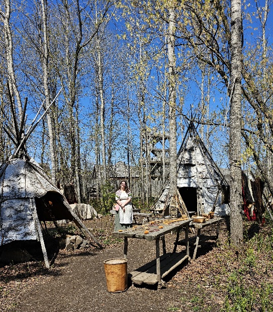
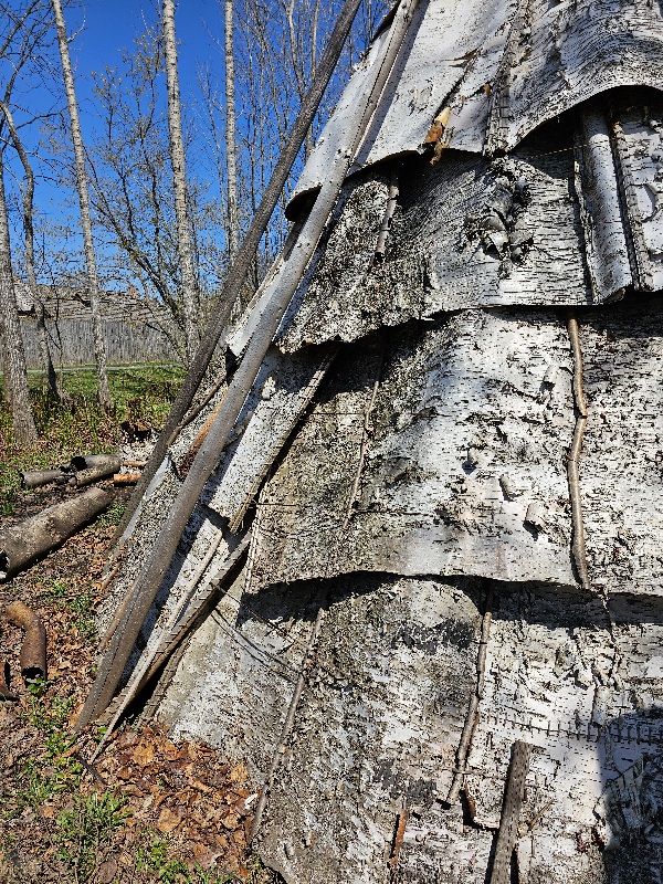

Anshinaabe/Ojibwe people crafted birchbark jiimaan (canoes) for the fur trade. A North Canoe was equal to about 25 beaver hides worth of trade goods. Traditional canoe building knowledge passed orally and by demonstration from generation to generation to create canoes that were durable, functional, and elegant. To produce quality canoes efficiently, labor was divided – men fabricated wooden elements and assembled canoes, women lashed and gummed them. They can be different shapes according to their function. Ricing canoes (for gathering wild rice), for example, are flatter to navigate shallower water and are propelled with poles to protect the fragile plants.


In its simplest economic terms the Canadian fur trade was the marriage of a demand in Europe for a particular fur, and the demand in North America among primitive tribes for certain products of Europe’s new and expanding industry. The most sought-after fur was beaver, in the ruthless pursuit of which the fur traders had to go farther and farther west and north. The fur trade was a decisive factor in determining Canadian boundaries—principally just west of Lake Superior, and in British Columbia.
When they arrived in North America, Europeans discovered an impressive transportation system used by Aboriginal peoples and consisting of a network of interconnected waterways. Providing natural access to Lake Superior and Hudson’s Bay, the country’s rivers and lakes were surprisingly navigable. This fact contributed greatly to westward expansion. Since land routes were almost non-existent and most colonies were established on the coast, the only way to travel inland was by water. The trade routes were rivers and lakes — and not necessarily peaceful reedy rivers, nor pleasant mirrored lakes. Canoe travel involved various obstacles, especially the weather, rough terrain, waterfalls, rapids and vast expanses of water. In the days of the NWC, voyageurs made the major river routes more passable by removing obstructions such as trees and beaver dams. They also cut back the underbrush, dug channels through swamps, and built bridges and stairways to make portages easier. In 1797, the NWC built a lock at Sault Ste. Marie in order to make it easier for canoes to travel around the rapids there.
The route west from Montreal has been called the ‘first Trans-Canada Highway’. It ran from near Montreal, up the Ottawa River, west up the Mattawa River to Trout Lake and over the 7 mile La Vase portage at what is now North Bay on Lake Nipissing and down the French River to Georgian Bay of Lake Huron, west through the Strait of Mackinac to Lake Michigan, or west north of Manitoulin Island and up the St Marys River (26 feet difference in elevation) to Lake Superior and on to Fort William. On Lake Superior voyageurs would normally hug the northern shore because of the danger of frequent squalls that could overturn their boats.


Two eras of the fur trade included the early French Era followed by the British. In the 16th century, cod fishermen began trading for furs, especially at Tadoussac on the St. Lawrence River. With the foundation of Quebec in 1608, Coureurs des bois spread out through the many rivers and lakes to trade with the Indians, while Indians would carry canoe-loads of fur down to Montreal. Nearby tribes became middlemen, drawing furs from further inland. Montreal was the main base where furs were stored before transshipment to Europe. The second era began when trade reached the pays d’en haut west of Lake Superior. In these cold lands beaver had longer and thicker fur. After the British conquered Canada in 1759, management of the Montreal trade was taken over by English-speakers while the real work continued to be done by French-Canadians ( which is why all the terminology is French).
We learned all this history in school beginning with the coureurs du bois and the voyageurs including the fur trade and the voyages of discovery all the way to the Pacific.
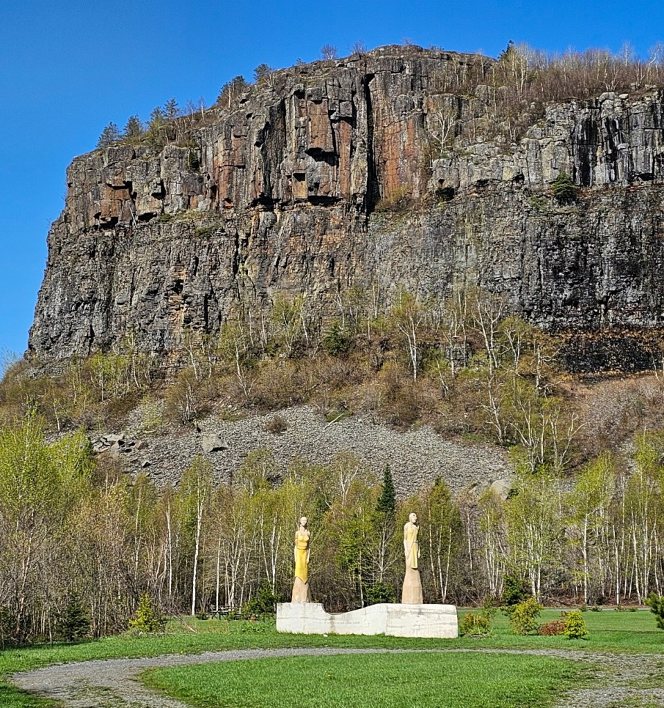
Mount McKay is a maficsill located south of Thunder Bay, Ontario, Canada, on the Indian reserve of the Fort William First Nation. It formed during a period of magmatic activity associated with the large Midcontinent Rift System about 1,100 million years ago.
McKay is traditionally known as the “Thunder Mountain” (Animikii-wajiw in the Ojibwe language and locally written as “Anemki-waucheu”). The mountain is used by the Ojibwe for sacred ceremonies. Only with the construction of the road did non-First Nations people get access to this land. A lookout exists on the lower eastern plateau, providing a view of Thunder Bay and the city’s harbour. A small memorial commemorates Aboriginal people that fought in wars. Animikii-wajiw is considered sacred ground by the members of the Fort William First Nation, on whose traditional territory the mountain stands.
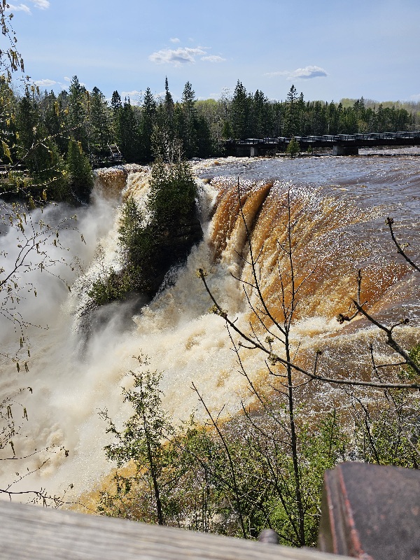
Kakabeka Falls
The falls have a drop of 40 m (130 ft), cascading into a gorge carved out of the Precambrian Shield by meltwater following the last glacial maximum. Because of its size and ease of access, it has been consequently nicknamed “the Niagara of the North”.
The rock face of the falls and the escarpments along the gorge are composed primarily of unstable shale, and are eroding. These rocks host sensitive flora, and contain some of the oldest fossils in existence, some 1.6 billion years of age. The name “Kakabeka” comes from the Ojibwe word gakaabikaa “waterfall over a cliff”
The Legend of Green Mantle is about an Ojibwe chief who upon hearing news of an imminent attack from the Sioux tribe instructs his daughter, Princess Green Mantle, to devise a plan to protect her people. She enters the Sioux camp along the Kaministiquia River and, pretending to be lost, she bargains with them to spare her life if she will bring them to her father’s camp. Placed at the head of the canoe, she instead leads herself and the Sioux warriors over the falls to their deaths, sparing her tribe from the attack. The legend claims that one can see Green Mantle when looking into the mist of Kakabeka Falls, a monument to the princess that gave her life to save her people. Other versions of the legend say she came across the Sioux herself, and later jumped out of the canoe ahead of the falls and swam to shore, leaving the Sioux to go over the falls, then ran back to the camp to warn her people
Ojibwa Tribes
The local first national people in the Thunder Bay area are Ojibwa/Chippewa.
The Chippewa Indians, also known as the Ojibway or Ojibwe, lived mainly in Michigan, Wisconsin, Minnesota, North Dakota, and Ontario. They speak a form of the Algonquian language and were closely related to the Ottawa and Potawatomi Indians. The Chippewas were allies of the French and French traders often married Chippewa women. Chippewa warriors fought with the French against the British in the French and Indian War. But political alliances changed with the times. During the American Revolution the Chippewas sided with the British against the Americans.
The Ojibwe (said to mean “Puckered Moccasin People”), also known as the Chippewa, are a group of Algonquian-speaking bands who amalgamated as a tribe in the 1600’s. They were primarily hunters and fishermen, as the climate was too cool for farming. A few bands of Ojibwe lived in southern Michigan.
The manufacture of maple sugar was one of the principal Indian industries. They produced large quantities, and of good quality. Having completed its manufacture for the year, they packed it in mokoks (vessels or packages neatly made of birch-bark) and buried it in the ground, where it was kept in good condition for future use or sale. Their sugar-making resources were, of course, almost unlimited, for groves of maple abounded everywhere
Organized into independent migratory bands, the Ojibwe were ideally suited to fur trade with the French. They moved according to a seasonal subsistence economy—fishing in the summer, harvesting wild rice in the fall, hunting, trapping, and ice fishing in the winter, and tapping maple syrup and spearfishing in the spring. Their main building material, wiigwaas (birch bark), could be transported anywhere to make a wiigiwam (lodge shelter). Social organization was somewhat egalitarian, and women played a strong economic role.
Many French fur traders married into and adopted Ojibwe culture.
Kakabeka Falls Provincial Park, established in 1955, covers 5 square kilometres (1.9 sq mi) and is managed by Ontario Parks. It surrounds the falls and extends along the Kaministiquia River, which was used centuries ago by voyageurs, who were the first Europeans to overwinter annually in northern Ontario. They used the Kaministiquia River as a major route to the northwest, with a 1.3 km (0.81 mi) mountain portage around the falls.
This was a beautiful day. We sat outside until about 10 pm. There was still light in the sky. We don’t need outdoor lighting.

You must be logged in to post a comment.